

NCERT Class 9 Geography Chapter 2 Notes in English: Shaping of the Earth's Surface
Complete study material for Class 9 Geography Chapter 2 "Shaping of the Earth's Surface" (Understanding Society: India and Beyond). Includes easy revision notes, detailed solutions for all 15 NCERT questions, intext questions, extra practice questions, and important diagrams related to plate tectonics, weathering, erosion, and natural disasters.
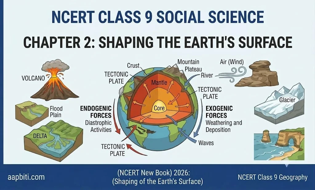


Chapter at a Glance
| Topic | Key Idea |
|---|---|
| Plate tectonics | Crust is broken into plates that move slowly over the semi-molten layer |
| Internal forces | Earthquakes, volcanoes, folding, faulting build the surface |
| External forces | Weathering, erosion, deposition wear down and reshape it |
| Agents of gradation | Running water, glaciers, wind, waves, groundwater |
| Disasters | Landslides, avalanches, GLOFs, dust storms |
Structure of the Earth
The Earth has three layers. The lithosphere is the crust plus the upper mantle. It is rigid and broken into plates. Below it lies the asthenosphere, a hot, semi-molten layer that lets plates move.
| Layer | Features |
|---|---|
| Crust | Outermost layer where we live; about 30–40 km thick under continents and 5–7 km under oceans |
| Mantle | Very thick and hot; about 2,900 km |
| Outer core | Fluid layer of iron and nickel |
| Inner core | Solid, hot, densest part of the Earth |
Plate Tectonics
The theory (given by W.J. Morgan) says the crust is divided into tectonic plates, which move a few centimetres a year. Plates are continental, oceanic or mixed. Major plates: Pacific, Eurasian, African, North American, South American, Indo-Australian and Antarctic.


Why do plates move?
Heat from the core makes molten material in the mantle rise while cooler material sinks. These convection currents push and pull the plates.
Types of Plate Boundaries
| Boundary | Movement | Result | Example |
|---|---|---|---|
| Convergent | Plates move towards each other | Fold mountains; or an oceanic plate sinks, causing volcanoes and earthquakes | Himalaya |
| Divergent | Plates move apart | Magma rises and forms new crust | Mid-Atlantic Ridge |
| Transform | Plates slide past each other | Earthquakes; no crust made or destroyed | San Andreas Fault, USA |
Most earthquakes and volcanoes occur along plate boundaries, especially around the Pacific Ocean, called the Ring of Fire.
Weathering and Erosion
| Point | Weathering | Erosion |
|---|---|---|
| Meaning | Rocks break into smaller pieces | Material is worn away and carried elsewhere |
| Movement | No movement of material | Involves movement by water, wind, ice, waves |
| Types | Physical, chemical, biological | Water, wind, glacial, coastal |
| Effect | Forms soil | Removes topsoil; damages farms, houses, roads |
Examples: temperature change and frost (physical), reaction with water or acids (chemical), plant roots splitting rocks (biological).


Agents of Gradation and Their Landforms
| Agent | Landforms | Use to Humans |
|---|---|---|
| Running water | V-shaped valleys, waterfalls (upper); meanders, oxbow lakes, floodplains (middle); deltas, levees (lower) | Farming, hydropower, irrigation, tourism |
| Waves and currents | Beaches, sand bars, cliffs, wave-cut platforms, caves, arches, stacks | Tourism, fishing, natural barrier |
| Glaciers | U-shaped valleys, cirques, aretes, hanging valleys, fjords; moraines (lateral, medial, terminal) | Skiing, trekking, fresh water, fertile soil |
| Wind | Yardangs, ventifacts, deflation hollows, desert pavements; barchan, longitudinal, star, parabolic dunes | Tourism, barriers against desertification |
| Groundwater | Caves, stalactites, stalagmites, sinkholes (Karst topography) | Fresh water, tourism, religious value |
A waterfall forms where hard rock lies over soft rock. A meander forms when a river erodes the outer bank and deposits on the inner bank. A delta forms at the river mouth where sediments are deposited, as in the Sundarbans.
Landforms and Disasters
| Disaster | Main Causes | Prone Areas | Mitigation | Recent Example |
|---|---|---|---|---|
| Landslide | Heavy rain, earthquakes, steep slopes, deforestation, mining, road building | Himalaya, Western Ghats, North-East hills | Plant trees, retaining walls, drainage, avoid hill construction | Wayanad, Kerala (2024) |
| Avalanche | Heavy snowfall, sudden warming, wind, skiing, vibrations | Himalayan snow zones such as J&K, Himachal, Sikkim | Early warning, snow barriers, avoiding risky slopes | Frequent in Siachen region |
| GLOF | Glacier melting, heavy rain, dam made of ice or moraine collapses | Himalayan glacial lakes | Monitor lakes, drain water safely, warning systems | South Lhonak Lake, Sikkim (2023) |
| Dust storm | Strong wind, drought, sparse vegetation, overgrazing | Thar desert, semi-arid regions | Shelter belts, more vegetation, better farming | Common in Rajasthan each summer |
Intext Questions: Answers
| Question | Answer |
|---|---|
| Let's Map: plate table | Pacific plate: mostly oceanic, Pacific Ocean. Indo-Australian plate: India and Australia, Indian Ocean. Eurasian plate: Europe and Asia, parts of Atlantic and Arctic. |
| Plate map vs earthquake and volcano map | Earthquakes and volcanoes cluster along plate boundaries. |
| Ring of Fire continents and countries | Asia, North America, South America, Oceania, Antarctica. Countries include Japan, Indonesia, Philippines, USA, Chile and New Zealand. |
| Does India face earthquake risk? | Yes. The Indo-Australian plate pushes into the Eurasian plate, so the Himalayan belt and Gujarat (2001) are vulnerable. High population density raises the loss of life. |
| Fig. 2.6 volcanic photograph | Cause: a volcanic eruption. Grey powder: volcanic ash. It shows strong internal forces and pressure of magma. |
| Erosion and farmers | Water and wind remove fertile topsoil, so crop yield falls. |
| Chamoli flood 2021 | Studies point to a rock and ice avalanche that sent a sudden debris-laden flood down the valley. |
NCERT Questions and Activities: Solutions
Q1. Sources of energy for internal forces
The main source is heat from the Earth's core and mantle, partly from radioactive decay. This heat creates convection currents, which move the plates. Gravity also helps pull plates and sinking material downward.
Q2. Physiographic divisions and endogenic forces
The Himalaya formed when the Indo-Australian plate collided with the Eurasian plate. The Northern Plains are made of river deposits in the trough south of the Himalaya. The Peninsular Plateau is an old, stable landmass shaped by ancient crustal movement and lava. The Andaman and Nicobar Islands are linked to plate movement and volcanic activity (mud volcano at Baratang).
Q3. Why and where do earthquakes occur? Can they be predicted?
Earthquakes occur when plates collide, separate or slide past each other and release stored energy. They are frequent along plate boundaries such as the Ring of Fire and the Himalayan belt. Exact prediction of time and place is not yet possible. Scientists can only identify earthquake-prone zones and prepare people.
Q4. Plate movements and distribution of earthquakes and volcanoes
Plate boundaries are zones of stress. At convergent boundaries, an oceanic plate sinks and melts, causing volcanoes and earthquakes. At divergent boundaries, magma rises. At transform boundaries, sliding causes earthquakes. So their map matches the plate boundary map.
Q5. Diagram of meander and delta
| Diagram | Draw and label |
|---|---|
| Meander | Winding river, steep bank (outer bend), bar (inner bend), oxbow lake |
| Delta | River entering sea, distributaries, islands or bars, sea |
Q6. Deforestation and erosion
Tree roots bind soil and leaves slow the falling rain. When forests are cut, soil becomes loose and is washed or blown away. This causes loss of fertility, floods and landslides. So more deforestation means more erosion.
Q7. Plan to protect local land from erosion
Plant trees and grass, build bunds and terraces on slopes, dig contour trenches, construct check dams on streams, avoid overgrazing, and keep soil covered with crops. The Zabo system of Nagaland is a good model.
Q8. Disasters in your region and mitigation
This depends on your area: floods and earthquakes in plains, landslides in hills, dust storms in deserts. A sample plan: identify risks, make an evacuation route, keep an emergency kit, learn first aid, and follow early warnings.
Q9. Model of landforms by underground water
Use clay or thermocol to build a limestone cave. Show stalactites hanging from the ceiling, stalagmites rising from the floor, a sinkhole at the top and an underground river. Label each part.
Q10. Precautions in an earthquake-prone region
Before: build strong houses, fix heavy furniture, keep an emergency kit. During: drop, cover and hold under a sturdy table; stay away from windows; if outside, move to an open space. After: expect aftershocks, avoid damaged buildings, and use stairs, not lifts.
Q11 to Q15 (Activities)
| Q. | How to Do It |
|---|---|
| 11 | Take an outline map of India or the world and mark this year's landslides, avalanches, GLOFs and dust storms with different symbols and a key. |
| 12 | Make a poster of a sacred landform nearby (river, hill, cave), with its folk story and picture. |
| 13 | Write a case study: what happened, when, who was affected, and effects on farming, travel, housing and jobs. |
| 14 | Translate the landslide safety poster into your mother tongue and display it at home. |
| 15 | Each group covers causes, impact on life and environment, and mitigation for water, wind or glacier. |
Extra Questions with Answers
| Question | Answer |
|---|---|
| 1. What is the lithosphere? | The crust plus the upper mantle; broken into tectonic plates. |
| 2. Which layer allows plates to move? | The asthenosphere. |
| 3. Name the boundary where plates slide past each other. | Transform boundary. |
| 4. How do the Himalaya form? | By collision of two continental plates (convergent boundary). |
| 5. Difference between weathering and erosion? | Weathering only breaks rock; erosion also carries material away. |
| 6. Define agents of gradation. | Natural forces that wear down, transport and deposit material. |
| 7. Which landform is shaped like a bowl at a glacier's head? | Cirque. |
| 8. What are stalactites and stalagmites? | Stalactites hang from cave roofs; stalagmites rise from cave floors. |
| 9. Why are deltas fertile? | Rivers deposit rich alluvial soil there; good for rice and jute. |
| 10. Why does a GLOF occur? | Glacier melt or heavy rain overfills a glacial lake and its ice or moraine dam breaks. |
Quick Revision and Memory Aids
| Remember | Trick |
|---|---|
| Boundaries | C-D-T: Come together, Drift apart, Touch and slide |
| Earth layers | Crust, Mantle, Core: outside to inside |
| River course | Upper cuts (V-valley), middle bends (meander), lower builds (delta) |
| Glacier landforms | Erosion: U-valley, cirque, arete, fjord. Deposition: moraine |
Conclusion: Internal forces build the Earth's surface and external forces carve it. Humans depend on these landforms for farming, water and tourism, but must also prepare for the disasters linked to them.

"Naina Saini is an Editorial Intern at Aapbiti, specializing in publishing and managing education-focused news articles. Operating under the direct mentorship and guidance of Shakti Rao Mani, the Product Owner of aapbiti.com, Naina is dedicated to delivering accurate, timely, and engaging academic updates. Her role focuses on keeping readers informed about educational trends, exams, admissions, and key academic policies."















Comments (0)